Discussion
Home ‣ Civil Engineering ‣ Tunnelling See What Others Are Saying!
- Question
Pick up the correct statement from the following:
Options- A. The topographical maps of the Survey of India are useful in the mountainous region for tunnelling.
- B. The height point on the ridge is fixed with the help of reciprocal ranging
- C. The accuracy of 1 in 10, 000 is required for planimetric control
- D. 1 second theodolite is used for angular measurement to achieve an angular error of 15 N where N is number of angles
- E. All the above.
- Correct Answer
- All the above.
- 1. A load of 500 kg was lifted through a distance of 13 cm. by an effort of 25 kg which moved through a distance of 650 cm. The efficiency of the lifting machine is
Options- A. 50%
- B. 40%
- C. 55%
- D. 30%. Discuss
- 2. A cantilever carrying a uniformly distributed load W over its full length is propped at its free end such that it is at the level of the fixed end. The bending moment will be zero at its free end also at
Options- A. mid point of the cantilever
- B. fixed point of the cantilever
- C. 1/4th length from free end
- D. 3/4th length from free end
- E. half length from free end. Discuss
- 3. If the peak discharge of a storm water drain (S.W. Drain) is e.xpected to exceed 150 cumecs, the free board to be provided, is
Options- A. 100 cm
- B. 90 cm
- C. 80 cm
- D. 50 cm. Discuss
- 4. Pick up the incorrect statement from the following :
Options- A. The mixture of water and waste products, is called sewage
- B. The treated sewage effluents, are generally used for irrigating the crops
- C. The process of collecting, treating and disposing off the sewage, is called sewerage
- D. The old convergency system was definitely better than water carried sewerage system
- E. None of these. Discuss
- 5. Monnier, the inventor of R.C.C., suggested the introduction of reinforced cement concert sleepers for the railways in
Options- A. 1857
- B. 1867
- C. 1877
- D. 1887
- E. 1897 Discuss
- 6. The self-weight of the footing, is
Options- A. not considered for calculating the upward pressure on footing
- B. also considered for calculating the upward pressure on footihg
- C. not considered for calculating the area of the footing
- D. both (b) and (c) Discuss
- 7. Softer variety of steel may be obtained by
Options- A. Cementation process
- B. crucible process
- C. Bessemer process
- D. Open hearth process. Discuss
- 8. To ensure uniform pressure distribution, the thickness of the foundation, is
Options- A. kept uniform throughout
- B. increased gradually towards the edge
- C. decreased gradually towards the edge
- D. kept zero at the edge. Discuss
- 9. For one cubic metre of brick masonry, number of bricks required, is
Options- A. 400
- B. 425
- C. 450
- D. 500
- E. 550. Discuss
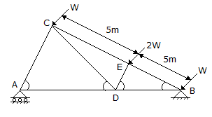
- 10. The direction of the reaction at support B of a truss shown in below figure will be

Options- A. East of North
- B. West of North
- C. East of South
- D. West of South
- E. Vertical. Discuss
More questions
Correct Answer: 40%
Correct Answer: 3/4th length from free end
Correct Answer: 100 cm
Correct Answer: The old convergency system was definitely better than water carried sewerage system
Correct Answer: 1877
Correct Answer: not considered for calculating the upward pressure on footing
Correct Answer: Bessemer process
Correct Answer: decreased gradually towards the edge
Correct Answer: 500
Correct Answer: East of North
Comments
There are no comments.More in Civil Engineering:
Programming
Copyright ©CuriousTab. All rights reserved.
